You do 1 , the rest is automatic
Get on the Grid with VB-RTK. For over a decade American surveyors have been using the National Geodetic Survey’s Online Positioning User Service. Surveyors employing RTK have been a significant share of the user segment of OPUS.
A significant share of OPUS users are surveyors using RTK. Often a surveyor will set up his base on a new, unknown position and allow an autonomous (or standalone) position to be used for the base coordinates. While he is performing his RTK work with fixed vectors between his base and rover, he stores data at the base to be submitted at a later time to OPUS. Once he is finished with his work, he downloads this file to his computer, converts the file if necessary, and submits it to OPUS. He then receives an email response back with a precisely determined coordinate for his base station. He then must take this coordinate, relate the coordinate to his project coordinate system, and then translate the work from the autonomous (or standalone) position he used in the field to this new coordinate. This procedure can produce excellent results and anchors the survey to the NSRS. The down side to this is that there are several steps that must be carefully observed and each of these error prone steps costs time.
With J-Field data collection software, Javad has been automating many tasks that surveyors have been doing for years, making the tasks more efficient and reducing sources of potential error. One example, "Verify RTK with V6 Resets", is being recognized by surveyors across the country as the most accurate and efficient way to confidently determine RTK positions. Rather than taking a shot, manually resetting (or dumping) the receiver and taking a second shot for comparison, Verify RTK does this automatically with a user defined number of reset iterations.
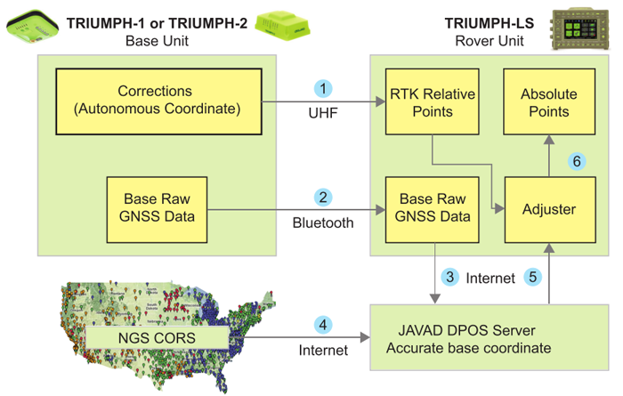
Javad has continued this automation philosophy by dramatically simplifying the process of translating a survey from an autonomous base position to precise geodetic coordinates with VB-RTK (Verify Base – RTK). Using the Javad GNSS, Data Processing Online Service (DPOS), which is powered by the proven Javad GNSS Justin processing engine. This multi-level process is done in J-Filed completely automatically.
Once an RTK session has been completed, the user returns to his Javad base receiver and presses “Stop Base” on the Triumph-LS. At this point, the raw data file that has been recording at the base during the session, is wirelessly downloaded from the base to the Triumph-LS. When the download is complete, the user returns to his office and connects the Triumph-LS to the internet.
When internet connection is made, the file is automatically transmitted to one of the Javad GNSS servers for post processing. Once data and ephemerides are available for the session, DPOS processes the file and returns results to the waiting Triumph-LS. This all takes within minutes.
Once results are returned, the new coordinates for the base are shown related to your coordinate system (including localization systems).
If the user is not satisfied with the results of the DPOS solution and wants ti revert back to the original RTK positions, he simply clicks "Undo". This process is immune to base instrument height errors because the internal vectors between base to rover are related to the antenna, not the ground point. So, an accidental entry for the base height of 543' instead of 5.43' can be resolved by VB-RTK.
In addition to the advantages of having your RTK base station near your work area, which gives you much more accurate and faster fixes, especially in difficult areas, and saving you the RTN chargest; perhaps most important of all, your work is now precisely related to one of the most accurate geodetic control networks in history - the NGS CORPS. Every rover point is only two vectors removed from the CORS (CORS to base, base to rover). This means that you can return again someday to find your monuments easily and accurately. This makes your records incredibly more valuable to both you and future surveyors. J-Field also has the unique ability to load and view every point you have ever surveyed from all the projects in its system. By combining this feature with a distance filter in its advanced set of filters, you can easily view all the points you have previously surveyed within a given distance of a point in your current project. Having an easily accessible record of nearby georeferenced coordinates is very beneficial as you may have previously located monuments in past surveys that are beneficial in your current project. J-Field allows you to easily copy these selected points into your current project, eliminating the need for you to resurvey them. All of this is available automatically on the world's most advanced RTK rover - the Triumph-LS.
You do 1 , the rest is automatic