JAVAD GNSS Triumph-LS Plus and Triumph-3
Brian Fisher, PS
You’ve come a long way… Survey! That’s the first message you see when you turn on the screen of the Javad Triumph-LS Plus, and boy are they not kidding. First a little history about me. I first purchased GPS equipment for myself and my burgeoning independent private land survey practice some twenty years ago. I wasn’t rolling in the big profits just yet, so I wanted to get as much bang for the buck as I could. This meant two things. First, I was shopping the used market and second, I wanted the most versatile equipment I could afford from a company that had the best products. Enter into the story, my longtime friend John Bergeson, a local survey equipment vendor, now retired, but more on him later at the end of this article. The gear I got back then included two Ashtech Z-Survey receivers, one as a base the other as a rover.
As time went on, I added several receivers to my kit of equipment, but I stuck with the “blue” brand, and had a Z-Extreme and several Pro-Mark receivers in a few years. I was impressed then by all the innovations that Javad Ashjaee was doing, and his legacy truly lives on in the company’s latest offering: the Triumph-3 and Triumph-LS Plus base rover combo.
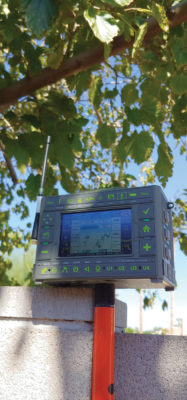
This is a powerhouse set of gear with some truly unique configurations. First it includes a fully integrated touchscreen on the Triumph-LS Plus. I’ve been told that Javad always had an affinity for the innovations Steve Jobs brought to the world, and much like Apple’s I-Phone, the touch screen on the Triumph-LS Plus lets you peer in through the window and see right into the heart of this equipment. Everything, quite literally, is at your fingers with this interface.
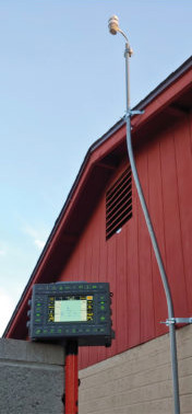
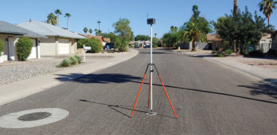
Like pretty much every manufacturer has done, the receiver, batteries and antenna are integrated in a single box on the top of the pole. What is different is the built-in data collector, right on the side. When I first spun this on my tried and true fixed two-meter rod I was initially skeptical because the screen was over my head, but after a fast rework of the rod to cut about a cubit (aka a foot and a half) I was off to the races with the screen right at eye level and easy to use. I’ve heard a lot of others talk about using collapsible rods and the full Javad kit comes with a very nice telescopic pole that is about this 5-foot length and very light weight. I guess I’m a bit old school, and if I’m hiking up a steep slope, my rover rod doubles as a walking stick, so I do tend to ask a lot of this equipment and prefer the heavier setup. As for the onboard screen, I ended up really liking it and think if I had to pick between an external device and this, I’d score the Javad higher.
Technical Specification
The Triumph-LS Plus tracks all the GNSS constellations, GPS, GLONASS, Galileo and BeiDou. It tracks 874 channels combined with three powerful processors and program memory in a single chip which uses less power and makes the total system less expensive. It also has four “Super Engines” RTK that mix and match different combinations of these constellations in real time for simultaneous comparison. This is a great feature and gives the field operator that warm and fuzzy feeling right as the data are being collected. It offers some really powerful wireless options such as Bluetooth and WiFi while still functioning in a low power consumption/long battery life (25 hour). There is built in CoGo, feature coding, attribute tagging, voice recording and two cameras. The camera can even be used to calculate offset points photogrammetrically. There’s even a downward pointing built in flashlight. These are just the highlights of what this receiver comes with.
Unboxing, getting started and my first job
One of the first things that I interacted with when unboxing the receivers was to get all the software and profiles updated by Javad technical support. From me cutting the packing tape to being online with Matthew Sibole, PLS. from Javad’s staff was very literally in just minutes. It took me longer to type in my own WiFi password than it did for Matt S. to log into my receivers and start working. I was very impressed with this feature, and while performing my field tests and review, I called back in several times for help. Every time proved seamlessly quick. Only caveat is this requires an internet connection. While I was at the home/office this was no problem. Out in the “field” this could be solved using a hotspot on a cell phone, but here in the wild west of Arizona, we still have 80% of our land mass well outside cell coverage. The second of the two jobs I did with this equipment I was “off grid” so to speak, as I was well outside cell coverage. Driving a few miles back to the interstate for cell coverage still beats going all the way back to town to try to get help, however. The software is amazingly intuitive, so even though some questions came up, I pretty easily figured it out on my own.
I did look through the printed manual, and it is organized well, but honestly, Matt walked me through enough of the configuration to get me going in less than an hour (with part of that time being used to get a Bluetooth radio paired, so I probably shouldn’t count that in the “training” time). I created a job, oriented my base location, started broadcasting and was tying in the block corners of a subdivision boundary (my house) right away. I coded the found evidence easily and even modified my code list right in the field to add a few codes that Matt didn’t have. It was easy to add photographs to each point collected. When the boundary was done, I was just a few configuration clicks away from transitioning into topography collection. The Triumph-LS Plus has an interesting feature that automatically senses when the rod is held static and plumb and starts the shot. To end the shot, you just walk away and it knows you’re moving and stores it automatically. Changing codes between shots is easily done with one click on the screen while holding the rod at an angle (so it doesn’t start taking a shot). I easily grabbed a few hundred shots on all the site walls, fences, utilities and concrete work. I was pretty impressed also with my ability to get in and around trees and buildings. It’s still intrinsically satellite surveying, so no going under a bridge to work, but I was pretty impressed with how far I was able to push the limit.
Finishing the job, post processing and reporting
The Triumph-LS Plus has a bunch of built-in software capability. I was able to edit codes, batch fix a rod height error I made on about a dozen shots in one command and delete a few erroneous topo shots where I forgot going “plumb” and “holding still” starts the shot! I remember calling that kind of rookie mistake a “beer leg,” meaning you set the tripod leg up on-line for taping (chaining) off a point. Maybe we need to rebrand the saying and call it a “beer point” when you accidentally take a topo shot. Exporting all the data was a simple process as well. In just a few keystrokes you can fully transfer your job to archive and export out just about every useful file format you can think of: text csv; drawing dwg; google kml; a full point by point PDF report that includes all the shot statistics, screen captures of the collection screen; photos, codes and notes. This can be done to a USB drive or to the “cloud” using Google Drive (internet connection depending).
Stakeout and searching for calculated positions
The Triumph-LS Plus has internal tilt/compass sensors so the screen knows what way you’re facing. A very handy feature when staking out a point is the screen (like a mini virtual dashboard) points you in the correct direction to face the point you’re looking for. It has all the other normal information: azimuth, distance, delta north and east; a map with the point and you on it, etc., but this moving arrow in the screen pointing in the correct direction is very intuitive and easy to use. There is also an additional accessory called the J-Tip that basically puts a magnetic locator at the bottom of your rod. One less item to carry when hunting for ferrous boundary corners is always a plus.
Geo-referencing and real-world position
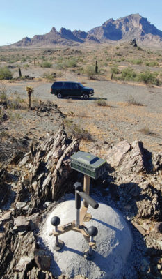
At the beginning of the job I had started on an “unknown” autonomous point. Not really as I already had an OPUS derived position from another time, but I held that back for blind comparison. The Triumph-3 base can be configured to log static data (and also has the capacity to perform static during RTK collecting as an additional check if you configure it to do so, but that could be an article in and of itself). Javad has a web service called DPOS that allows you to upload static files right from the Triumph-LS Plus using an internet connection in as little as an hour after you finish the job. Javad processes the file (again a process worthy of its own article to unpack everything) and on the user side it comes back as a “CORS” tied position. It’s just a few clicks to reprocess all the raw observed vectors and voila, your job is fully georeferenced to the National Spatial Reference System! I independently checked this in two ways. First against a previous OPUS observation and second by using the Javad JPS2RIN software to convert the base file into an OPUS consumable static RINEX file. Everything checked within several millimeters as one would expect.
Overall impressions
I’m super impressed. When I first saw the screen on the side of the receiver I said, “who moved my cheese,” if you’re familiar with that book about change and resistance to it. After using the Triumph-LS Plus for a couple jobs, I loved it. I found that the “top heaviness” you might anticipate really isn’t an issue. For control and boundary mark measuring, I usually have a rod with some sort of bracing (bipod or tripod) and that evened out the weight very well. For Topo, the five-foot rod balanced just below the receiver, and I was able to walk easily with it slanted near horizontal. Back in the early days of satellite surveying, not losing an initialization (view and “lock” on the sky) was nothing short of an art form. The Triumph-LS Plus gains initialization so quickly and holds lock so well, this is really a thing of the past and procedures where you try not to lose lock are probably going to go by the wayside just like constellation visibility planning did once there was a full constellation. How long ago was that, fifteen or more years now? I actually can’t remember. Technical support dialing right into my screen and even being able to hit the buttons was unmatched by anything I’ve seen on other brands of gear. Lifetime firmware and software updates is also a plus. Most importantly though, I got up and running right away. Within an hour I was surveying and that same day I had confidence in my data and delivered the job. Bottom line, I can’t beat that.
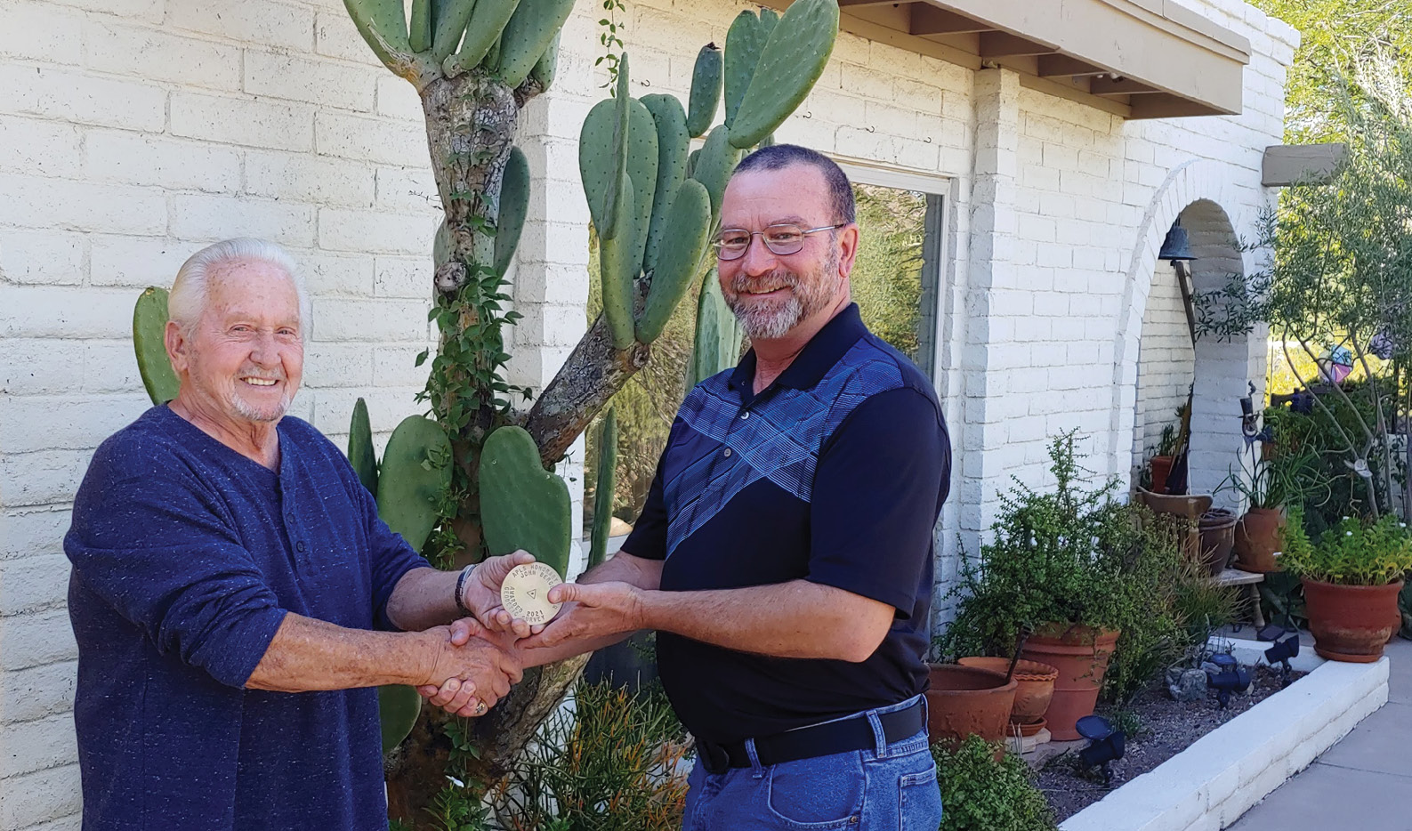
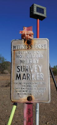
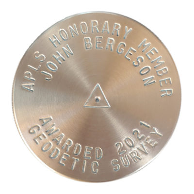
So, back to the story of my friend John Bergeson. John’s been in the industry in one form or another since 1969. Officially he retired in 2008, but he’s still enjoying the golden year and gets out to rockhound and recover the odd survey mark. A bunch of years ago John asked me if I could name a survey mark after him. I agreed, but you know how one thing leads to another and time gets away from you, so it never seemed to happen. I’ve come to realize that if you don’t sit down with a specific intention to get something done, it just never will happen. When Allen Cheves came to me with the idea to review this equipment, we were brainstorming ideas on how to put a human side to a technical review. The idea popped into my head to incorporate my first and now most recent experience with equipment inspired by Javad Ashjaee. That’s where the survey mark for John came in too. John sold me my first Ashtech, with financing terms that were, well, unheard of in the industry. I learned early on that people that bend the rules and push the envelope, to write their own script to the part they play, are the ones you want to associate with most of the time. It was a well-received idea for us in the Arizona Professional Land Surveyors (APLS) association to nominate John Bergeson to be an “Honorary Member” for life. Gifting him a survey mark named after him is just a small token of thanks that we all have for his years of dedication.
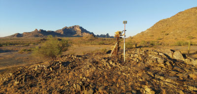
As part of this equipment test I used the Triumph-LS Plus and the Triumph-3 to observe static data and accessory objects (swing ties) for references to the control station. You can see John’s mark by searching the NGS database for PID BBHN29. Using Javad DPOS is a very efficient way to reference your data and using NGS OPUS-Share is the next logical step to archiving your control data for further public benefit. To quote the NGS, “Your data helps maintain local ties to the National Spatial Reference System (NSRS). Your shared solutions will also help your community prepare for the NSRS modernization.” More information is on the NGS website: geodesy.noaa.gov/OPUS/about.jsp#FAQ.
Brian Fisher is a professional land surveyor in Arizona. He is also the volunteer Arizona State Geodetic Coordinator for the National Geodetic Survey.